Sankar J. Nath | Trinath Mahato | Varsha Goswami |
Introduction
The potential emergence of La Niña in late 2024 brings both anticipation and uncertainty regarding its impact on India’s winter climate. Historically, La Niña winters in India are marked by colder-than-usual conditions in northern regions, driven by intensified cold waves, while southern states often experience cooler temperatures due to altered atmospheric circulation patterns.
As winter 2024 approaches, meteorologists and climate scientists are predicting what could become one of the coldest winters in India’s history. The anticipated harsh chill has sparked widespread interest, with many asking: what’s causing it? The answer lies in the influence of a significant natural phenomenon known as La Niña.
La Niña, the cooler sibling of the more commonly known El Niño, is a climate pattern with far-reaching impacts on global weather systems. For India, this phenomenon often translates to harsh winters, intensified cold waves, and extreme weather events. While La Niña’s effects are not new, the combination of this natural cycle with other climatic factors could make this winter exceptionally severe.
Understanding La Niña is crucial not only for preparing for the ongoing cold season but also for comprehending its broader implications on agriculture, health, and energy demands.
In this blog, we will delve into the science behind La Niña, explore its historical precedents, and examine why this winter could be a record-breaking one for India. Let’s uncover how this oceanic phenomenon works, its past impacts, and what lies ahead as we brace for an icy season.
What is the La Niña Effect?
La Niña, much like its counterpart El Niño, is a climate phenomenon with profound impacts on global and regional weather patterns. Often linked to extreme weather events such as heavy rainfall, droughts, or cold waves, La Niña’s effects are complex and vary widely across the globe. In India, its influence is particularly significant during the winter and monsoon seasons, shaping climatic trends and altering atmospheric dynamics.
The term “La Niña,” Spanish for “The Little Girl,” refers to a periodic cooling of sea surface temperatures in the central and eastern tropical Pacific Ocean. These cooling events typically occur every 2 to 7 years and are characterized by stronger-than-usual trade winds that intensify the upwelling of cold water in the eastern Pacific. This results in sea surface temperatures in the Niño 3.4 region—a critical area for monitoring the phenomenon—dropping at least 0.5°C below the long-term average. The greater the deviation from the norm, the stronger the La Niña event and its potential to disrupt global weather patterns, including intensifying winters in some regions (Figure 1).
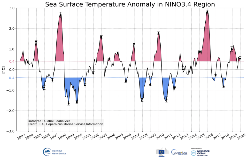
Figure 1: Sea surface temperature anomalies in the Niño 3.4 region from 1993 to 2020. Negative anomalies (in blue) indicate La Niña events, while positive anomalies (in red) represent El Niño events. The Niño 3.4 region is critical for tracking the strength and duration of these phenomena. Source: E.U. Copernicus Marine Service Information.
Role of the Walker Circulation and Trade Winds
At the heart of La Niña’s mechanics lies the ‘Walker Circulation’, a vast system of air circulation across the tropical Pacific:
Neutral Conditions: Under typical circumstances, warm air rises over the western Pacific near Southeast Asia, leading to low-pressure systems and abundant rainfall. In the eastern Pacific, cooler air descends, creating high-pressure zones and drier conditions explained in Figure 2.
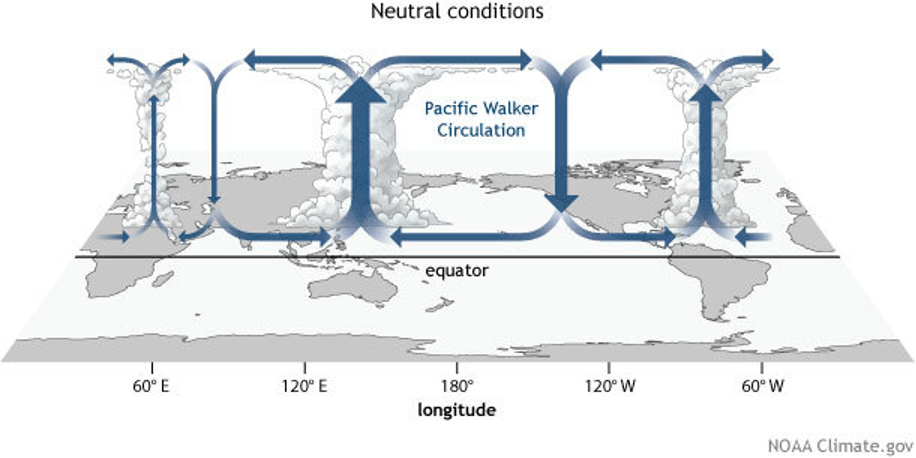
Figure 2: Generalized Walker Circulation (December-February) during ENSO-neutral conditions. Convection associated with rising branches of the Walker Circulation is found over the Maritime continent, northern South America, and eastern Africa. (Source: NOAA Climate.gov drawing by Fiona Martin).
La Niña Conditions: During La Niña, the Walker Circulation intensifies. Stronger trade winds push warm surface waters further westward, allowing colder, nutrient-rich water to rise to the surface in the eastern Pacific. This results in enhanced convection (rainfall) over the western Pacific, including South Asia, and colder sea surface temperatures in the Niño 3.4 region (Figure 3).
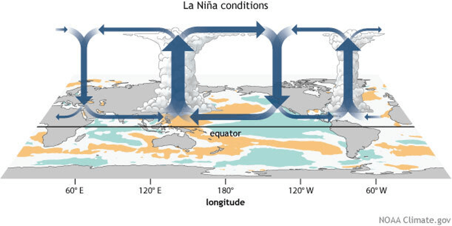
Figure 3: Generalized Walker Circulation (December-February) anomaly during La Niña events, overlaid on map of average sea surface temperature anomalies. Anomalous ocean cooling (blue-green) in the central and eastern Pacific Ocean and warming over the western Pacific Ocean enhance the rising branch of the Walker circulation over the Maritime Continent and the sinking branch over the eastern Pacific Ocean. Enhanced rising motion is also observed over northern South America, while anomalous sinking motion is found over eastern Africa. (Source: NOAA Climate.gov drawing by Fiona Martin).
The Expected Impact of La Niña on India’s 2024 Winter
India’s 2024 winter could be influenced by developing La Niña conditions, which are expected during December-February 2024, according to the India Meteorological Department (IMD). Currently, the ENSO (El Niño-Southern Oscillation) and IOD (Indian Ocean Dipole) conditions are neutral, with the neutral IOD likely to persist for the next few months (Figure 4).
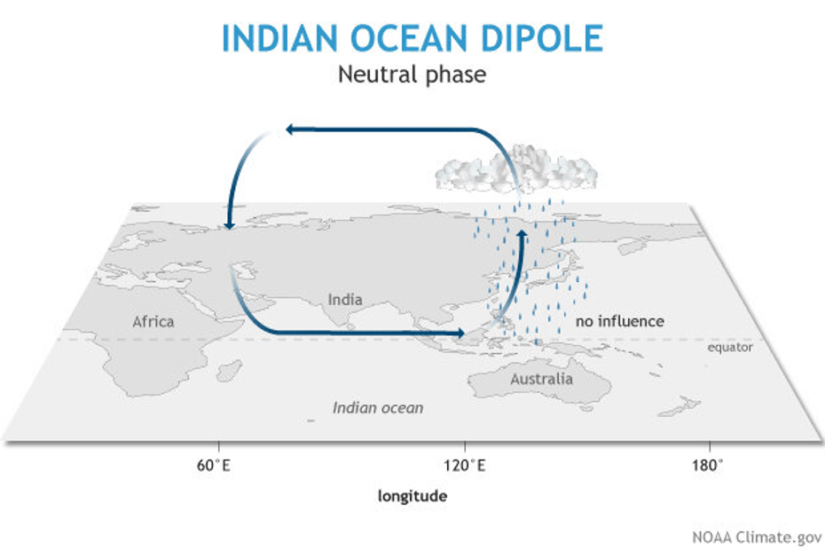
Figure 4: Neutral phase of Indian Ocean Dipole
However, with the current Oceanic Niño Index (ONI) hovering below the La Niña threshold, the onset remains uncertain and could delay winter in the north. If La Niña strengthens later in the season, northern India may experience a sharp drop in temperatures, particularly in January and February, increasing the likelihood of severe cold waves. On a broader scale, La Niña winters are associated with faster winds, which can improve air quality by dispersing pollutants. However, the accompanying lower planetary boundary layer height (PBLH) could trap pollutants near the surface, particularly in colder regions where biomass burning is prevalent. This interplay could pose a significant challenge to managing air quality in densely populated areas.
These conditions may lead to higher energy demands for heating, increased biomass burning, and deteriorated air quality, especially in urban hubs like Delhi-NCR. Conversely, southern India, already experiencing an unusual chill, may see prolonged cooler conditions. Future studies can explore energy demands driven by regional climatic circulations.
For agriculture, extended cold spells could impact frost-sensitive Rabi crops such as wheat and mustard, potentially reducing yields. Yet, La Niña’s potential persistence into 2025 offers some optimism: it could moderate the extreme heatwaves that often accompany El Niño summers and support robust monsoon rainfall, replenishing water resources and aiding agriculture.
Conclusion
The looming La Niña in 2024 brings both challenges and opportunities for India. While colder winters and intensified cold waves may strain energy demands and impact air quality, the phenomenon could also moderate summer heatwaves and enhance monsoon rains in 2025, benefiting agriculture and water resources. The delayed onset adds uncertainty, but preparation through accurate forecasts and adaptive measures can help mitigate its adverse effects. This winter serves as a reminder of the need for resilience and proactive planning in the face of evolving climate patterns.
References:
- National Oceanic and Atmospheric Administration
- India Meteorological Department
- “How does La Niña affect India’s climate? | Explained” by Mohammad Rafiuddin ,Shikhar Tiwari,Rishikesh P., The Hindu, December 17, 2024
- L’Heureux, M. (2014). The Walker Circulation: ENSO’s atmospheric buddy. National Oceanic and Atmospheric Administration (NOAA) Climate.gov. Retrieved from https://www.climate.gov/news-features/blogs/enso/walker-circulation-ensos-atmospheric-buddy

