Trinath Mahato |
Recognising the pivotal role of forests in environmental balance, economic progress, and societal well-being is crucial, especially their potential to mitigate the harmful impacts of climate change. Understanding this, the Indian government has rolled out a series of initiatives promoting afforestation, reforestation, and forest conservation. Such endeavours reflect India’s dedication to global commitments, notably the Paris Agreement. Under this pact, India has set an ambitious goal to develop an additional carbon sink capable of absorbing 2.5 to 3 billion tonnes of CO2 equivalent by expanding its forest and tree cover by 2030. Post-independence, India established its forest policy in 1952. ‘India Forest Statistics’ highlighted that around 59.77 million hectares of forests existed in 1949-50, making up 18% of the country’s total land. Fast forward to the ‘India State of Forest Report 2015’, the combined forest and tree cover had expanded to 79.42 million hectares, equivalent to roughly 24.61% of the land area. Impressively, recent data shows a growth of 1,540 square kilometres in forest cover from 2019 to 2021, as per the comparisons between ISFR 2019 and ISFR 2021. The latest ISFR report indicates that India’s forest cover stands at 7,13,789 square kilometres, a rise to 21.7% of the country’s area, with an additional tree cover spanning 96,748 square kilometres.
Among all the state five states that recorded the highest increase in forest cover are Andhra Pradesh (of 647 sq. km), Telangana (632 sq. km), Odisha (537 sq. km), Karnataka (155 sq. km) and Jharkhand (110 sq. km).
The Government of India has implemented several noteworthy measures and policies to support afforestation, as mentioned below:
- Green India Mission (GIM): As part of the National Action Plan on Climate Change, GIM is dedicated to protecting, restoring, and enhancing India’s forest cover, with a focus on addressing climate change.
- Compensatory Afforestation Fund Act (CAF Act), 2016: This legislation is designed to ensure the conservation and development of forests. The CAF sets up funds in the public account of India and in each state specifically for afforestation and reforestation activities.
- National Afforestation Program (NAP): This program seeks to expand forest and tree cover by afforesting and reforesting degraded forest regions and adjacent lands. A unique feature of NAP is its emphasis on involving local communities in both the planning and execution phases.
- Joint Forest Management (JFM): JFM fosters collaboration between local communities and authorities for the management and restoration of degraded forests. This approach not only helps protect forests but also ensures that local communities benefit from forest resources.
- National Agroforestry Policy, 2014: This policy advocates for integrating trees into agricultural fields and landscapes. The overarching goals are to bolster tree cover, safeguard biodiversity, and uplift livelihoods.
- National Biodiversity Authority (NBA) and State Biodiversity Boards (SBBs): These entities were established to champion biodiversity conservation, promote the sustainable use of its components, and ensure the fair distribution of benefits derived from biological resources.
- Urban Forestry Initiatives: These initiatives aim to enhance green spaces in urban settings by planting trees in public parks, along roadsides, and in any other suitable areas.
Remote Sensing Application in Forestry
Remote sensing and GIS act as a critical tool in addressing land-related challenges and issues such as desertification, shifts in land use and cover, forest degradation, deforestation, reforestation, and urban sprawl, among others. Various indices, derived from spectral bands, are employed to delineate these issues. One such prominent index is the NDVI (Normalized Difference Vegetation Index). NDVI is commonly used in remote sensing to gauge the health, density, and vitality of vegetation. Essentially, it acts as a barometer for detecting live green vegetation on our planet. The NDVI is computed as the difference between near-infrared (NIR) and red (RED) reflectance divided by their sum.
The NDVI is calculated using the following formula:
NDVI = (NIR – RED)/(NIR + RED)
Where:
NIR = Reflectance in the near-infrared band.
RED = Reflectance in the red band.
And NDVI values ranges between -1 to 1 each class of the NDVI have their own set of meanings.
Value Range:
-1 to 0: Indicates non-vegetative surfaces like water, snow, clouds, and barren areas.
0 to 0.2: Represents barren landscapes with minimal or no vegetation.
0.2 to 0.4: Indicates grassland or scrublands.
0.4 to 0.6: Represents moderate dense vegetation
0.6 to 1: Represents dense vegetation such as forests
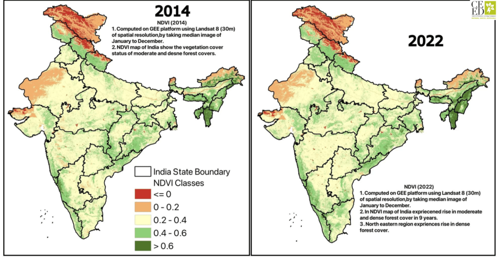
The Normalized Difference Vegetation Index (NDVI) offers a wide range of applications, from assessing vegetation health and monitoring droughts to classifying land cover, forecasting crop yields, managing forests, and studying climate change, many others. The NDVI, which is derived using remote-sensing (satellite) data, is closely linked to drought conditions. Leveraging tools like Google Earth Engine (GEE) and R programming have capacity to quantifying various remote sensing Indices and studies, NDVI assessments for India were conducted for two distinct years, 2014 and 2022. These evaluations reveal contrasting vegetation health and coverage for the two periods. Historically, the NDVI map of India has been segmented into five categories, and comparing these classifications paints a vivid picture of the country’s vegetation progression. A glance at the NDVI statistics (table 1) reveals a noticeable increase in forest cover density in India from 2014 to 2022, particularly within the 0.4 to 1 range, indicating moderate to dense forests. Conversely, areas falling below the 0.4 NDVI value have seen a decline. Most notably, the 0.2 to 0.4 class, which typically represents transitional zones like grasslands or scrublands, has witnessed a significant reduction by -88833.12 sqkm. This suggests that areas categorised as grasslands or scrublands are now benefiting from the Indian government’s afforestation efforts and restoration initiatives. Regionally, states such as Mizoram, Nagaland, Manipur, Tamil Nadu, Gujarat, and Haryana have seen an uptick in forest cover. In contrast, states like Arunachal Pradesh, Tripura, and Meghalaya have experienced a reduction. Such analyses are invaluable for forest management in India, offering a snapshot of the country’s forest health and cover. It’s an excellent tool for alerting or informing the population about the state and well-being of India’s forests which is very crucial in mitigating climate change and natural disaster like landslide in hilly regions, floods etc. after ocean forest cover act as a second-largest storehouse of carbon and helps in increasing resilience to the local communities such as providing clean air and water, helps to regulate the climate and buffer natural disaster such as flood and wildfires. Even forest act as carbon sink which absorbs upto 2.4 billion metric tons carbon each year.
Recently, Reuters published an article on “India succeeds in reducing emissions rate by 33% over 14 years – sources”
Stated that India’s greenhouse gas emissions intensity dropped by 33% between 2005 and 2019, surpassing expectations due to increased renewable energy production and forest cover growth. The country’s efforts in expanding forest cover, promoting non-fossil fuel generation, and targeting emissions in various sectors have contributed to this significant reduction. As of 2019, 24.56% of India is covered by forests. According to the latest ISFR report 2021, the total forest and tree cover in India is 80.9 million hectares, which is 25.62% of the TGA of the country. Meanwhile, India is also focusing on green hydrogen production.
This progress puts India on track to achieve its commitment to the United Nations Convention on Climate Change (UNFCCC) of reducing emissions intensity by 45% from 2005 levels by 2030. The rate of reduction grew to 3% annually from 2016-2019, up from 1.5% between 2014-2016, primarily due to the government’s emphasis on renewables. However, fossil fuels still dominate India’s energy mix. Non-fossil fuel-based power accounts for 25.3% of India’s total power generation. However, thermal power still dominates at 73%. The G20 nations recently struggled to agree on fossil fuel phase-out and emission cut targets. Developing countries like India argue that industrialized nations’ extensive fossil fuel usage has exhausted resources.
And the question arises how rise on forest cover acts as reduction of CO2 emissions or as CO2 sink ?
And the answer is trees, plants and algae “breathe in” CO2 from the atmosphere. Using sunlight, converts atmospheric CO2 and water into organic compounds (glucose) to grow.
The general equation for photosynthesis is:
6CO2 + 6H2O + light energy → C6H12O6 + 6O2
Here, C6H12O6 represents glucose, a simple sugar that plants use as an energy source or convert into other types of organic molecules. During this process, the carbon from CO2 is integrated into plant’s structure, effectively removing it from the atmosphere. This process is called photosynthesis, while doing this, trees and plant release oxygen. As trees grow they accumulate biomass in their stems, leaves, roots and branches, this biomass stored carbon. Larger trees, with their extensive trunks and root systems, can store significant amounts of carbon over long periods. Forest cover helps soils to store carbon too. Forest soils are rich in organic matter, which is primarily composed of dead plant material. As this material decomposes, some of the carbon becomes integrated into the soil structure, forming stable compounds that can persist for centuries or even millennia. Young and Regenerating forests tend to absorb CO₂ at a higher rate than mature forests because they are in a rapid growth phase. However, mature forests store a vast amount of carbon in their biomass and soils. Sustainable forest management practices, such as selective logging and promoting natural regeneration, can enhance a forest’s role as a carbon sink. Conversely, deforestation and forest degradation release stored carbon back into the atmosphere. When trees are cut down and burned or left to rot, the carbon in their biomass is converted back to CO₂. Forests act as carbon sinks through a combination of biological processes (like photosynthesis), physical storage (in biomass and soils), and human-induced activities (like sustainable forest management). Their role in the global carbon cycle is crucial for mitigating the effects of climate change.
NDVI Classes | Area in Sqkm (2014) | Area in Sqkm (2022) | Change in Sqkm (2014-2022) |
-1 to 0 | 106279.94 | 105984.99 | -294.95 |
0 to 0.2 | 410703.53 | 365471.17 | -45232.36 |
0.2 to 0.4 | 1980129.94 | 1891296.82 | -88833.12 |
0.4 to 0.6 | 736647.78 | 852436.76 | 115789 |
0.6 to 1 | 76205.02 | 94776.47 | 18571.45 |
Table 1: India NDVI map classified into 5 distinct classes and Area in sqkm.