Trinath Mahato |
On World Desertification Day, it’s crucial to recognize the tools and indices used to monitor and combat desertification and drought in highly vulnerable states like Jharkhand which have 68.72 % of degraded land. Advanced remote sensing techniques and indices such as the kernel Normalized Difference Vegetation Index (kNDVI), Palmer Drought Severity Index (PDSI), and soil moisture measurements play vital roles in understanding and managing the health of our ecosystems and help policy makers to build policies to slow the desertification process.
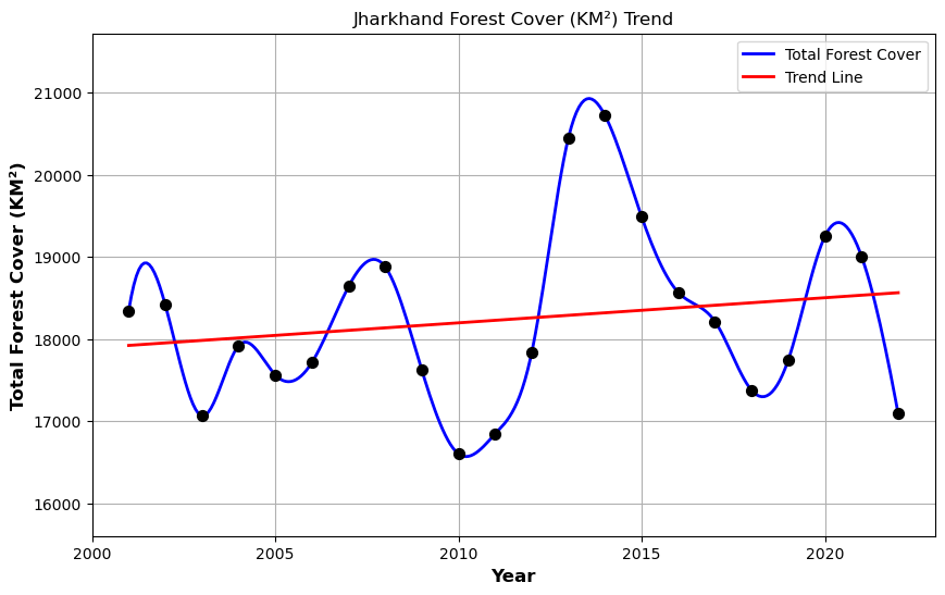
Vegetation Dynamics with kNDVI
The kernel Normalized Difference Vegetation Index (kNDVI), a remote sensing index for land surface and biological analysis, to monitor vegetation dynamics, evaluate land management practices, and assess ecosystem health. It shows an increasing trend in the vegetation cover as well as the health of the forest cover; higher values are proportional to healthy vegetation, and vice versa. Forest cover scenario in the state: approximately 30.57 square kilometers per year, signifies the average annual increase in total forest cover in Jharkhand.

Assessing Drought with PDSI – Palmer Drought Severity Index
Using widely accessible temperature and precipitation data, the PDSI estimates relative dryness. It is a standardized indicator with a range of -10 (dry) to +10 (wet), which can be used to assess long-term drought. By seeing the PDSI Jharkhand values, it is evident that Jharkhand has faced long-term drought conditions in recent decades, which is critical for population and water management in densely populated clusters. From 2001 to 2023, except for the years 2014, 2020, 2021, and 2022, Jharkhand faces wet conditions. The rest of the year, Jharkhand experiences drought-like conditions. As shown in the PDSI animation, drought conditions are primarily dominant in the western part of Jharkhand.
Importance of Soil Moisture
Soil moisture is a pivotal component in various environmental and agricultural contexts, including agricultural surveillance, drought and flood prediction, forest fire anticipation, and water resource management. The monthly trend of soil moisture from 2001 to 2023 shows seasonal changes in the moisture content. In general, the monsoon and post-monsoon seasons face good amounts of soil moisture ranging from 200 to more than 300 mm. More precisely, the districts of Giridih, Bokaro, Dhanbad, Deoghar, Jamtara, Dumka, Gumla, and some parts of Khunti face lower soil moisture conditions in all seasons compared to other districts.
World Desertification Day underscores the urgent need for proactive measures to combat desertification and drought. Deserification not only threatens biodiversity and ecosystem health, but also alters agricultural productivity and water availability. In Jharkhand, the deployment of advanced remote sensing indices like kNDVI, PDSI, and soil moisture plays a crucial role in monitoring and managing environmental health. These tools not only provide essential insights into current conditions but also enable strategic planning for sustainable development. By leveraging remote sensing technologies, community-level engagement, and government . initiatives effectively, Jharkhand can enhance its forest resilience, optimize water resource management, and mitigate the impacts of drought and desertification on its communities and ecosystems. Continuous monitoring and targeted interventions will be key to ensuring a path towards environmental sustainability, resilience against desertification, and a healthier ecosystem for better livelihoods for its inhabitants. ensuring a greener, more sustainable future for the state.